BACKGROUND
Art VULUPS is the result of a ten-year assemblage of relationships encompassing geography, environmental science, land use planning, sustainability, art and creativity concepts. During this time, many individuals have contributed with ideas, suggestions and time; they have also helped define the meaning, purpose and scope of this project. Its realization has only been possibly by the genuine embrace of a number of progressive, community-based institutions. Certain elements such as adventure, risk, careful observation and reflection have played an instrumental role in providing for the necessary inspiration, momentum and excitement that all together form the concept of Art as a Vehicle to Understand Land Use Planning and Sustainability Project.
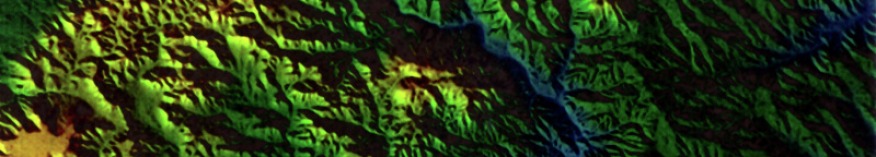
DEM
Art VULUPS is a journey that began in 1999 at California State Northridge. I was studying towards an Urban Geography degree (eventually I changed to Urban Studies and Planning). One of the last assignments for a research class led by Dr. William Bowen was to develop a DEM (Digital Elevation Model). This fascinating approach of generating a three-dimensional, relief shaded representation of the earth's crust on a two-dimensional surface captivated my attention. I selected the Temecula area, located in Riverside County, CA, because of a unique ecological preserve- the Santa Rosa Plateau.
Producing the DEM involved obtaining digital files from the U.S. Geological Survey and processing them through MAC DEM, a special software designed to translate contour line data into an aerial-like (or satellite-like) view image. This technology was one of the major paving components for what we know today as Google Earth.
The end result was quite striking, and after manipulating the image in Adobe Illustrator, I decided that I was not seeing a map anymore; before me I had created a form of digital art. As such, it had to be displayed properly in a picture frame. Luckily, I had been a professional picture framer and gallery owner; so I knew how to proceed. I selected a frame deep enough to create a shadow box effect. I used a stack of twelve mats in order to present the piece as a work of art. The range of colors represented the same color spectrum shown in the DEM where red depicted the highest elevation and blue the lowest elevation. The gradient in between was comprised of different shades of orange, yellow, and green. To add more effect I used sawing string to delineate the nine 7.5 minute topographical quads used in the creation of this DEM.
Once completed, I presented the piece to the class. Dr. Bowen was particularly intrigued and showed it around to some of his colleagues at the Geography Department. Eventually the piece was exhibited at the Department's semester showcase, generating informal geographical discussion among the students exposed to the piece. This was my personal discovery that art has a tremendous power to ignite one's curiosity and imagination.
SPRAWL
It was not until 2003 when I saw exactly what I wanted to do. The University of California Riverside had organized the exhibit entitled "Sprawl: New Suburban Landscapes" at the Sweeney Art Gallery in conjunction with the then-proposed Center for Sustainable Suburban Development. On a rainy day, I attended the exhibit by myself. The minute I walked in, I entered into a dimension in which my urban planning profession was challenged by a group of artists. The works were critical renditions of subtle unsustainable planning practices. Some of the pieces were more memorable than others. The first one I can recall was a sizable agave plant made out of plastic, with a blooming flower that instead of having buds had "disguised" telecommunications antennas.
Another piece that struck me was a large canvas ("Rancho Dorado", by Jean Lowe) that at first glance appeared as if it had been painted at the turn of the century when the California hills were romanticized by Impressionism artists. As I got closer to look at the detail, I realized that the fabulous gilded frame was also painted on the canvas and that the enormous rolling hill was being rough graded in preparation for track home development. The scene reminded me of the time when, after interviewing Mr. Richard O'Neill at his restaurant in San Juan Capistrano, I took a drive into the northeastern rolling hills that were being carved into what we know today as the community of Ladera Ranch in Orange County. Finally, the aerial depictions of artist Nikko Mueller truly inspired me and catapulted me into creating my own mixed media art. His renditions were precise, simple and easy to read from an urban planning perspective. I could see subdivisions, roads, water basins, open space and many other man-made features.
Another piece that struck me was a large canvas ("Rancho Dorado", by Jean Lowe) that at first glance appeared as if it had been painted at the turn of the century when the California hills were romanticized by Impressionism artists. As I got closer to look at the detail, I realized that the fabulous gilded frame was also painted on the canvas and that the enormous rolling hill was being rough graded in preparation for track home development. The scene reminded me of the time when, after interviewing Mr. Richard O'Neill at his restaurant in San Juan Capistrano, I took a drive into the northeastern rolling hills that were being carved into what we know today as the community of Ladera Ranch in Orange County. Finally, the aerial depictions of artist Nikko Mueller truly inspired me and catapulted me into creating my own mixed media art. His renditions were precise, simple and easy to read from an urban planning perspective. I could see subdivisions, roads, water basins, open space and many other man-made features.
CCAPA
I had no idea how to go about becoming a Nikko Mueller's clone, so I decided to do my own thing. For starters, I did not want to work alone. My initial efforts to collaborate with other planners and artists included submitting proposals for presentations at the 2004 California Chapter of the American Planning Association (CCAPA) Conference in Palm Springs and the 2005 International Society of City and Regional Planners (ISOCAP) Conference "Innovative Communities." It was not until three years ago, however, when all my networking efforts paid off. I responded to a call for presentations for the 2008 CCAPA Conference in Hollywood, CA, which included a "Lecture-Salon Couplet" session organized by the California Planning Roundtable. This session was designed to discuss "out of the box" planning topics and thinking, and my approach to explaining basic land use and sustainability concepts with art seemed like a good fit. After discussing my proposal with the moderator James Rojas, a cutting edge urban planner and sui generis artist, I was included in a panel focused on public art. In preparation for the conference I created "Milieux," which is a collection of five mixed media pieces that encapsulate land use planning and sustainability concepts. Additionally, I began to mold the Art VULUPS collaborative component, in which other planners and artists would participate in the creation of land use art. The presentation was well received; to the extent that I was later invited to lead a lecture at the University of Southern California.
Soon after the conference, I went to the Inland Empire Section of the American Planning Association's Board and re-introduced the concept. The Board voted to endorse it and provided an initial funding amount of $500 to initiate implementation. Additionally, Brian Moore and Meenaxi Panakkal joined me in defining Art VULUP's vision, mission and goals. Since then, other talented individuals have joined the leadership team and the project has received support from a number of organizations, including the Inlandia Institute, the Riverside Arts Council and the California Planning Foundation. And now, here we are, with the aspiration to empower our community by sharing our knowledge, talents and time.
Soon after the conference, I went to the Inland Empire Section of the American Planning Association's Board and re-introduced the concept. The Board voted to endorse it and provided an initial funding amount of $500 to initiate implementation. Additionally, Brian Moore and Meenaxi Panakkal joined me in defining Art VULUP's vision, mission and goals. Since then, other talented individuals have joined the leadership team and the project has received support from a number of organizations, including the Inlandia Institute, the Riverside Arts Council and the California Planning Foundation. And now, here we are, with the aspiration to empower our community by sharing our knowledge, talents and time.